

§ 6.13. Community Form Standards.
A.
Purpose and Intent. The purpose and intent of this section is to establish community form standards for development in the greenfield and under-developed portions of the City. More specifically, this section is intended to:
1.
Support street development as an integral component of community design;
2.
Provide safe, efficient, and convenient vehicular, bicycle, and pedestrian access and circulation patterns within and between developments;
3.
Maintain the carrying capacity of the county's major arterial streets;
4.
Foster a pedestrian-friendly distribution of land uses and street network;
5.
Assure safe access to and from streets by emergency vehicles; and
6.
Reduce interference with through traffic by other vehicles, bicycles, or pedestrians entering, leaving, and crossing streets.
B.
Applicability.
1.
General. Unless exempted in accordance with paragraph 4 below, or except where otherwise expressly stated, the standards in this section apply to all new development west of Interstate 95.
2.
Time of Review. Review for compliance with the standards in this section shall take place as part of the review of an application for:
a.
Planned Development (see Section 3.4.F);
b.
Special Use Permit (see Section 3.4.G);
c.
Public or Semipublic Use Permit (see Section 3.4.H);
d.
Site Plan (see Section 3.4.I);
e.
Certificate of Appropriateness (see Section 3.4.J); or
f.
Building Permit (see Section 3.4.R).
3.
Conflict. In the case of conflict between these standards and other standards in this Code, the more restrictive standard shall control. The more restrictive standard shall be the one that further limits development potential, seeks to provide a greater measure of compatibility protection, or retains or protects existing native vegetation or natural resources.
4.
Exemptions. The following forms of development are exempt from the standards in this section:
a.
Development on a single lot or tract where no new street rights-of-way are proposed; and
b.
Development where no modifications to existing street rights-of-way are proposed.
C.
Street Standards. All streets shall be developed in accordance with the standards in this section and the standards in Section 7.2.D, Streets.
D.
Internal Street Connectivity.
1.
Minimum Connectivity Index Score Required. All development subject to these standards shall achieve an internal street connectivity score in accordance with Table 6.13.D.1, Minimum Street Connectivity Index.
Table 6.13.D.1: Minimum Street Connectivity Index
Zoning District Where Development
is Proposed
Minimum Connectivity Index Score Residential and Industrial Districts 1.30 Business Districts 1.50 Planned Development Districts 1.70 2.
Connectivity Index Score Calculation. The connectivity index for a development is calculated by dividing its links by its nodes. Figure 6.13.D.2 provides an example of how to calculate the connectivity index. Nodes (stars) exist at street intersections and cul-de-sac heads within the development. Links (circles) are stretches of road that connect nodes. Street stub-outs are considered as links, but temporary dead-end streets internal to a development or alleys are not counted as links. One link beyond every node that exists in the development and provides access to the street system outside the development shall be included in the index calculation. In the diagram, there are 36 links (circles) and 21 nodes (stars); therefore the connectivity index is 1.71 (36/21 = 1.71).
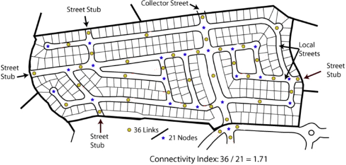
Figure 6.13.D.2: Street connectivity index.
3.
Reduction in Minimum Index Score. The minimum connectivity index score may be reduced if the owner/developer demonstrates it is not possible to achieve due to natural features, existing road configurations, or adjacent existing development patterns. In these instances, internal street design shall achieve as high a connectivity index score as reasonably practical.
4.
Pedestrian Connections Required.
a.
A right-of-way eight-feet-wide for pedestrian/bicycle access between a cul-de-sac head or street turnaround and the sidewalk system of the closest adjacent street or pedestrian pathway (as shown in Figure 6.13.D.4: Pedestrian connections.) shall be required whenever the City staff determines a proposed cul-de-sac or street turnaround:
i.
Is in close proximity with significant pedestrian generators or destinations such as schools, parks, trails, employment centers, or similar features; or
ii.
Creates an unreasonable impediment to pedestrian circulation.
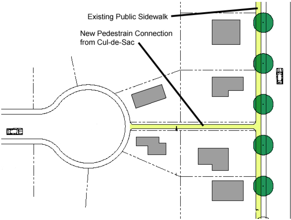
Figure 6.13.D.4: Pedestrian connections.
b.
This pedestrian connection shall count as a link for the purpose of calculating the connectivity index.
E.
External Street Connectivity.
1.
The arrangement of streets in a development shall provide for the alignment and continuation of existing or proposed streets into adjoining lands where the adjoining lands are undeveloped and deemed appropriate for future development in the comprehensive plan or are developed and include opportunities for such connections.
2.
Street rights-of-way shall be extended to or along adjoining property boundaries such that a roadway connection or street stub shall be provided for development where practicable and feasible in each direction (north, south, east, and west) for development that abuts vacant lands.
3.
At all locations where streets terminate with no street connection, but a future connection is planned or accommodated, a sign shall be installed with the words "FUTURE ROAD CONNECTION" to inform property owners.
4.
The final plat (see Section 3.4.K.5) shall identify all stub streets and include a notation that all street stubs are intended for connection with future streets on adjoining undeveloped or underdeveloped lands.
5.
Stub streets that exceed 150 feet in length shall include a turn-around.
F.
Continuation of Adjacent Streets. Proposed street layouts shall be coordinated with the existing street system in surrounding areas. Existing streets shall, to the maximum extent practicable, be extended to provide access to adjacent subdivisions and to provide for additional points of ingress and egress.
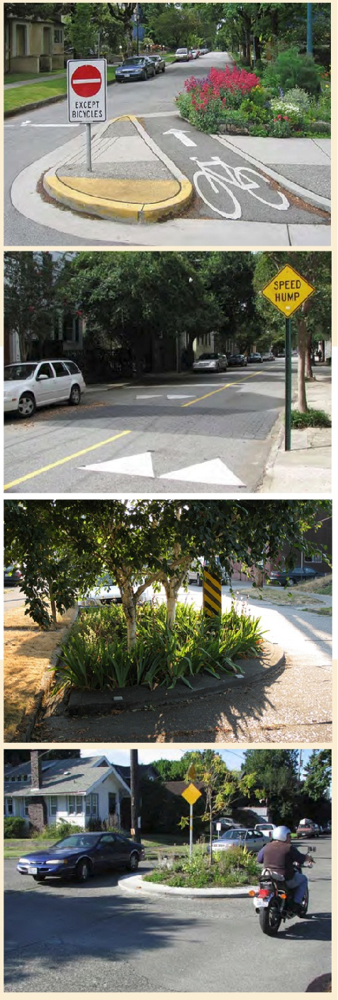
Figure 6.13.G, Traffic calming measures.
G.
Traffic Calming Measures.
1.
Minimal street widths, short block lengths, on-street parking, controlled intersections, roundabouts, and other traffic calming measures are encouraged on all local, and subcollector streets, provided they do not interfere with emergency vehicle access.
2.
Residential development organized around a grid street network shall employ measures to interrupt or terminate linear street segments over 800 linear feet long, to the maximum extent practicable (see Figure 6.13.G, Traffic calming measures.). Such measures shall include, but shall not be limited to:
a.
Stop signs at street intersections;
b.
Roundabouts, or traffic circles;
c.
Curvilinear street segments to slow traffic and interrupt monotonous streetscapes;
d.
Roadway striping to limit vehicular cartway widths or accommodate bike lanes; and
e.
Speed tables or elevated pedestrian street crossings.
3.
Sidewalk bulb-outs are discouraged on streets less than 28 feet wide, but are encouraged on wider streets as a traffic calming device and to reduce crossing distance for pedestrians, where practicable.
H.
Block Design.
1.
Block Length. Block length shall be at least 200 feet, but no more than 1,000 feet. City staff may allow deviations from these block length standards on determining that:
a.
Environmental or topographic constraints exist;
b.
The site has an irregular shape;
c.
A longer block will reduce the number of railroad grade or water body crossings; or
d.
Longer blocks will result in less traffic through residential subdivisions from adjoining businesses or areas.
2.
Block Width. To the maximum extent practicable, the width of any block shall be sufficient to permit at least two tiers of lots of appropriate depth for the zoning district exclusive of any public alleys, watercourses, or other right-of-way located outside platted lots.
3.
Mid-Block Access. In cases where a block length exceeds 800 feet, sidewalks or multi-use paths shall be provided mid-block to connect parallel sidewalks on the long side of the block.
I.
Development Entry Points.
1.
Unless exempted in accordance with paragraph 3 below, all subdivisions shall provide access from the development to the street system outside the development in accordance with Table 6.13.I, Required Subdivision Access:
Table 6.13.I: Required Subdivision Access Development Type Minimum Number of Access Points Residential Use Types (By Number of Units)
≤80 units 1 81 - 160 units 2 >160 units 3 All Other Use Types (By Site Area)
<5 acres 1 5 - 20 acres 2 >20 acres 2 + 1 per every additional 20 acres 2.
Nothing in this section shall limit the total number of streets providing access to the street system outside a development, or exempt a development from meeting all applicable external street connectivity standards.
3.
Development shall be exempted from these standards if it is demonstrated the following conditions apply:
a.
No other street access points can be located due to existing lot configurations, absence of connecting streets, environmental, or topographic constraints;
b.
FDOT will not authorize the required number of entrances; or
c.
Alternative access can be provided in a manner acceptable to the City that is supported by a transportation impact analysis.
J.
Sidewalks. Sidewalks shall be required along streets in accordance with Section 7.2.E, Sidewalks.
K.
Street Trees. Street trees shall be required to serve all development in the City in accordance with the following:
1.
Where Required. Except where exempted in paragraph 2 below, street trees shall be required along both sides of all streets with a service level of collector or above.
2.
Exemptions. Street trees shall not be required for:
a.
Agricultural uses in the AG district, except when agricultural land is subdivided for new residential development; or
b.
Lots for single-family detached dwellings.
3.
Location.
a.
All street trees shall be planted between the back of the curb and the sidewalk (see Figure 6.13.K.3, Street tree placement.).
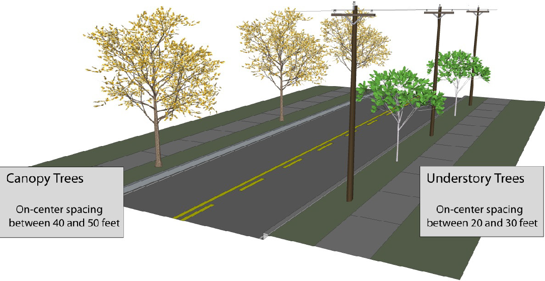
Figure 6.13.K.3, Street tree placement.
b.
In cases where street trees cannot be planted between the curb and the sidewalk, applicants shall contact the City staff for approved street tree locations in the public right-of-way.
4.
Configuration.
a.
Street trees shall be shade trees except beneath overhead utilities or other projections into the public right-of-way, where small trees shall be used instead.
b.
All trees planted along FDOT rights-of-way shall conform to FDOT guidelines.
c.
A root barrier shall be installed around the roots of trees where adjacent to a curb or sidewalk.
5.
Maximum On-Center Spacing.
a.
Shade trees shall be spaced between 40 and 50 feet on center.
b.
Small trees shall be spaced between 20 and 30 feet on center.